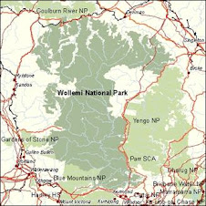
See interactive course map at right, or go to bottom to see full map.
The route follows all the correct ridges, junctions, trails and creeks that my more detailed topo-map plan has, this blog version is roughly drawn with Map My Run.
However, you should be able to understand the general route. The detailed route plan on my Memeory Map software measures the trip as 160ks, however this is only horizontal distance.
The Traverse is 160 southerly Grid squares from start to finish (not including east- west movement), and covers 13 Topo maps.
The only trail walking is approx 10ks of Westerly trail walking along the Hunter Main Trail, and 5-6ks of Easterly trail walking along the Army Rd/ Wirraba FT. This is to get in position to hit the best South running ridge tops in the Park.
Go South Young Man, South!
Thursday, August 27, 2009
Wednesday, August 19, 2009
The 2008 Trips Food drop - missing Beijing Olympic opening ceremony
The trip, now to be referred to as The Travese, was initially attempted in September 2008. Numerous hours were spent planning, getting equipment, and one full weekend getting to and burying a food drop on the Wirriba Ridge Fire Trail somehwere between Brick Hill and Mt Wirraba.
The food drop in prepration for the 2008 Traverse was conducted on the weekend of the 08/08/08 and involved parking near Mellong Creek on Putty Rd, walking West around Long Wheeny Farm via the L.W Creek, then along Putty Creek to where it meets Wollemi Creek, then up the old 1960s Fire Trail (keeping Dumball Creek on your left). Trick for young players: this track isn't on your new photographic topos. I found it by Google Earth and old topos.
Following research, I also found out that the Wirriba FT was built by an Army Engineering unit from 1RAR before it left for Vietnam in the early 1960's. I found unit engravings of "15PL, C Coy 1RAR" on a major rock cutting they did in building the Trail.
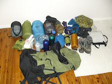
The food drop included 4 days food with the plan being to reach this point in 4 or 5 days from Baerami - it took 7 days! and it was only half way.
The food drop in prepration for the 2008 Traverse was conducted on the weekend of the 08/08/08 and involved parking near Mellong Creek on Putty Rd, walking West around Long Wheeny Farm via the L.W Creek, then along Putty Creek to where it meets Wollemi Creek, then up the old 1960s Fire Trail (keeping Dumball Creek on your left). Trick for young players: this track isn't on your new photographic topos. I found it by Google Earth and old topos.
Following research, I also found out that the Wirriba FT was built by an Army Engineering unit from 1RAR before it left for Vietnam in the early 1960's. I found unit engravings of "15PL, C Coy 1RAR" on a major rock cutting they did in building the Trail.
The food drop included 4 days food with the plan being to reach this point in 4 or 5 days from Baerami - it took 7 days! and it was only half way.
Wednesday, August 12, 2009
Route being finalised for release
While the first half of the trip was completed in September 2008, final changes to the route have been made recently, including a more direct route onto the Wirraba Ridge FT near Gospers mtn.
Subscribe to:
Posts (Atom)