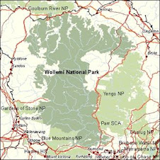
See interactive course map at right, or go to bottom to see full map.
The route follows all the correct ridges, junctions, trails and creeks that my more detailed topo-map plan has, this blog version is roughly drawn with Map My Run.
However, you should be able to understand the general route. The detailed route plan on my Memeory Map software measures the trip as 160ks, however this is only horizontal distance.
The Traverse is 160 southerly Grid squares from start to finish (not including east- west movement), and covers 13 Topo maps.
The only trail walking is approx 10ks of Westerly trail walking along the Hunter Main Trail, and 5-6ks of Easterly trail walking along the Army Rd/ Wirraba FT. This is to get in position to hit the best South running ridge tops in the Park.
Go South Young Man, South!
Subscribe to:
Post Comments (Atom)

What about water?
ReplyDelete